|
|
|
|
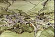
This is a birds eye view of Clun in the south-west of Shropshire. To the west of the view you can see St George's church, which dates from the Nor...
|
|
|
|
|
|
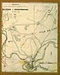
The Battle of Shrewsbury took place in 1403, just north of Shrewsbury at a place that is now known as Battlefield. The church at the north of the m...
|
|
|
|
|
|
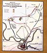
This sketch of the Battle of Shrewsbury was found in a collection of the Rev. E. P. Owen's watercolours and clippings. The battle took place outsid...
|
|
|
|
|
|
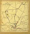
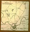
This is a map laying out all the crucial features relating to the Battle of Shrewsbury in 1403. To the left hand side you can see the Shelton Oak, ...
|
|
|
|
|
|
This is a view of Shrewsbury during the Battle of Shrewsbury in 1403. The key on the right of the map allows you to work out where King Henry and ...
|
|
|
|
|
|
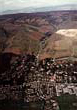
An aerial view of Church Stretton and Cardingmill Valley in 1990 does not do justice to the steepness of the valleysides. If you don't mind height...
|
|
|
|
|
|
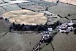
The circular cropmark in the yellow field towards the centre of the picture is the only visible remains of a bowl barrow at Acton Bank. The barrow...
|
|
|
|
|
|
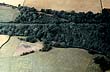
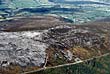
An aerial photograph was taken in 1976 to accompany small-scale excavations at Weir Meadow, close to the Roman villa site of Whitley Grange to the ...
|
|
|
|
|
|
An ancient trackway called the Portway crosses the top of the Long Mynd (left of picture). It joins up with a long distance bridleway, the Jack Myt...
|
|
|
|
|
|
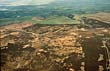
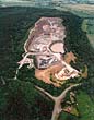
This aerial view reveals the quarry at Haughmond Hill which is well hidden by the surrounding woodland. Aggregate Industries can only expand downw...
|
|
|
|
|
|
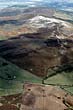
The rocks exposed on the ridge are known as Stiperstones Quartzite, and are of great interest to geologists. The rocks are of Ordovician age, whic...
|
|
|
|
|
|
The stone stripes of the Stiperstones were formed by alternate freezing and thawing during the last Ice Age. Stripes and patches of rock probably b...
|
|