|
|
|
|
This view of the path along the ridge of the Stiperstones looks almost otherworldly. In places such as this it can certainly be tough going under ...
|
|
|
|
|
|
A touch of winter frost keeps the visitors away from Cardingmill Valley. Despite being a very popular beauty spot, there are always times when it i...
|
|
|
|
|
|
An ancient trackway called the Portway crosses the top of the Long Mynd (left of picture). It joins up with a long distance bridleway, the Jack Myt...
|
|
|
|
|
|
The rocks exposed on the ridge are known as Stiperstones Quartzite, and are of great interest to geologists. The rocks are of Ordovician age, whic...
|
|
|
|
|
|
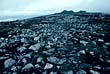
The stone stripes of the Stiperstones were formed by alternate freezing and thawing during the last Ice Age. Stripes and patches of rock probably b...
|
|
|
|
|
|
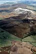
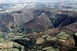
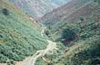
The western slope of the Stiperstones ridge is cut by several steep-sided deep valleys. The main two in this photograph are Perkins Beach in the f...
|
|
|
|
|
|
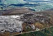
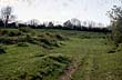
This uneven grassy area near Stokes Barn, Much Wenlock, is the remains of former limestone quarrying. Beneath the grass are the remains of work...
|
|
|
|
|
|
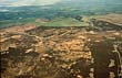
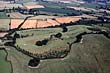
Arscott Golf Course has been open for 10 years. Massive old oak and beech trees can be seen on the course along with abandoned mine and brick worki...
|
|
|
|
|
|
Arscott Golf Course lies in rolling countryside just south west of Shrewsbury near Cruckmeole and Hanwood. It is a young course that looks older on...
|
|
|
|
|
|
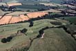
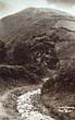
Ashes Hollow is one of the most beautiful valleys on the Long Mynd and is accessible from a camp site at Little Stretton. Photographed by National ...
|
|
|
|
|
|
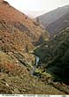
Ashes Hollow is one of the many hollows, valleys and cutaways that make up the base of the Longmynd. It was formed over 20,000 years ago, when the...
|
|
|
|
|
|
Ashes Hollow was formed over 20,000 years ago, when the melt waters and ice that covered Shropshire scraped and gouged their way through the Church...
|
|